What else can GPS tell us?
Interview with
Navigation technology can sometimes surprise us by helping in other areas, like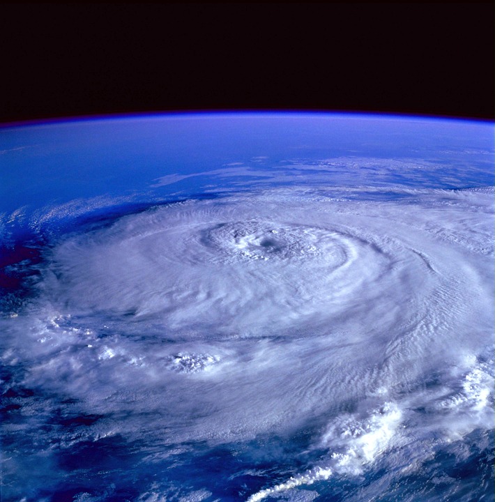 for instance monitoring weather or flooding. Because, signals sent down from GPS satellites bounce back spacewards, where they can provide us with valuable information. From Surrey Satellites, Martin Unwin explained the technique to Chris Smith...
Martin - Back in 2003 we decided to do an experiment to find out whether these signals were bouncing off the Earth's surface and off the oceans. So we put an experiment up on a satellite called UKDMC, which took a mouthful of data, just 20 seconds at a time, then sent it down to the ground and we processed that using a software GPS receiver and then we found out that there were reflections which we could pick up from space.
Then we thought one step further - this should contain information about the surface of the Earth.
Chris - Because it's bounced off it?
Martin - Because it's bounced off you might use a term geophysical imprint. If you've got a rough surface then it will spread the signal out. Whereas if you've got a calm flat surface then it will be a clean reflection.
Chris - So how could you use that data then, in those reflections?
Martin - The biggest application we think is for measuring the roughness of the sea surface. So we can measure the distance between a calm sea and a rough sea and, taking it one step further, we think this could be a good system for measuring the reflections in the middle of a hurricane, which could then be used to understand what's going on inside one of these storms.
Chris - Are people not already doing that though?
Martin - There are satellites in orbit - radio scatterometers. They have higher frequencies so they have a problem in that they are blocked by rain and the kind of environment a hurricane would see. Whereas GPs signals go straight through that and get to the ocean surface.
Chris - Is it just water, or can you get interesting information over land as well?
Martin - We've been looking at reflections off water, and we've been looking at reflections off ice and land. And yes, we can see reflections from all of those. The reflections off the land are showing up some very intriguing return patterns. So we're seeing vegetation tends to absorb signals, mountains tend to scatter it, but we are also seeing that dry land will tend to reflect it differently to wet land. And so there is the potential for measuring the moisture which is a very important parameter for climate science.
But NASA is now using our instrument on a constellation called Cygnus and that's due to be launched this December, and their specific objective is to look at hurricanes.
Chris - And so that will mean rather than just one satellite getting a snapshot over one particular trajectory of the Earth's surface, if you've got a constellation of them you're going to get a much more comprehensive coverage, aren't they?
Martin - That's right, and this is the exciting thing about Cygnus. There's eight satellites which are being launched together and these aren't big satellites because we're only talking about a modified GPS receiver. They are able to do this with a satellite that's only about 25 kilogrammes. A heavy suitcase would be heavier than that. They will be trying to find reflections in the middle of hurricanes but, of course, most of the time there aren't hurricanes so they'll still be taking measurements over the ocean which is going to be something very new.
Chris - And these strange anomalies on the ground - is that area 51?
Martin - We have seen some things which are possibly man made interference. So there are some interesting features that we are seeing in our data - yes!
- Previous New therapy for phobias
- Next Finding our way through space


 crystal")

Comments
Add a comment